Facebook
Instagram
MAPS
Delaware
Rehoboth Beach to Sussex Shores
Bethany Beach to Ocean City
Florida
Florida Keys — Upper Keys
Florida Keys — Middle Keys
Florida Keys — Lower Keys
Maryland
Chesapeake Bay – Havre de Grace to Middle River
Chesapeake Bay – Taylors Island to Bloodsworth Island
Chesapeake Bay – Sandy Point to Herring Bay
Chesapeake Bay – Middle River to Sandy Point
Chesapeake Bay – Herring Bay to Taylors Island
Chesapeake Bay – Bloodsworth Island to Smith Point
Mass.
Martha’s Vineyard, MA
Nantucket Island, MA
New Hampshire
Portsmouth to Seabrook
New Jersey
Manasquan to Sandy Hook
Seaside Heights to Point Pleasant
Long Beach Island
Atlantic City, Brigantine Area
Sea Isle City to Ocean City
Cape May, Wildwood
Long Beach Island, NJ circa 1900
A General Plan of Barnegat Light, NJ
A GENERAL PLAN OF BEACH HAVEN, NJ
Shark Attack Map
New York
Revised Riverhead to Montauk
Jones Beach to Fire Island
Fire Island to Moriches Inlet
Rhode Island
A General Plan of Newport, Rhode Island
A General Plan of Block Island, RI
South Carolina
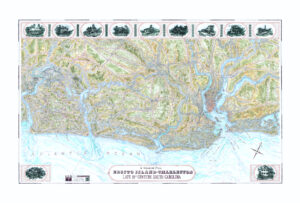
South Carolina Sea Islands—Edisto Island to Isle of Palms
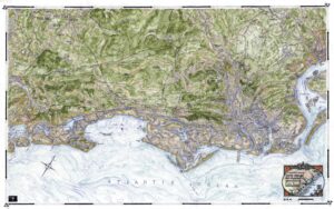
South Carolina Sea Islands—Daufuskie Island to Fripp Island
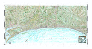
South Carolina Sea Islands—Capers Island to Cat Island
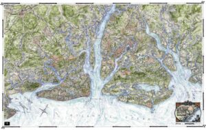
A General Plan of South Carolina—The Grand Strand—Pawleys Island to Myrtle Beach
A General Plan of Edisto Island to Charleston, Late 19th Century South Carolina
Texas
Rockport to Corpus Christi
Virginia
Chesapeake Bay – Smith Point to Windmill Point
Chesapeake Bay – Windmill Point to Wolf Trap
Chesapeake Bay – Wolf Trap to Fishermans Island
Chesapeake Bay – Fishermans Island to Virginia Beach
CRAFTSMANSHIP
THE MAPMAKER
CONTACT
BLOG
0
MAPS
Delaware
Rehoboth Beach to Sussex Shores
Bethany Beach to Ocean City
Florida
Florida Keys — Upper Keys
Florida Keys — Middle Keys
Florida Keys — Lower Keys
Maryland
Chesapeake Bay – Havre de Grace to Middle River
Chesapeake Bay – Taylors Island to Bloodsworth Island
Chesapeake Bay – Sandy Point to Herring Bay
Chesapeake Bay – Middle River to Sandy Point
Chesapeake Bay – Herring Bay to Taylors Island
Chesapeake Bay – Bloodsworth Island to Smith Point
Mass.
Martha’s Vineyard, MA
Nantucket Island, MA
New Hampshire
Portsmouth to Seabrook
New Jersey
Manasquan to Sandy Hook
Seaside Heights to Point Pleasant
Long Beach Island
Atlantic City, Brigantine Area
Sea Isle City to Ocean City
Cape May, Wildwood
Long Beach Island, NJ circa 1900
A General Plan of Barnegat Light, NJ
A GENERAL PLAN OF BEACH HAVEN, NJ
Shark Attack Map
New York
Revised Riverhead to Montauk
Jones Beach to Fire Island
Fire Island to Moriches Inlet
Rhode Island
A General Plan of Newport, Rhode Island
A General Plan of Block Island, RI
South Carolina
South Carolina Sea Islands—Edisto Island to Isle of Palms
South Carolina Sea Islands—Daufuskie Island to Fripp Island
South Carolina Sea Islands—Capers Island to Cat Island
A General Plan of South Carolina—The Grand Strand—Pawleys Island to Myrtle Beach
A General Plan of Edisto Island to Charleston, Late 19th Century South Carolina
Texas
Rockport to Corpus Christi
Virginia
Chesapeake Bay – Smith Point to Windmill Point
Chesapeake Bay – Windmill Point to Wolf Trap
Chesapeake Bay – Wolf Trap to Fishermans Island
Chesapeake Bay – Fishermans Island to Virginia Beach
CRAFTSMANSHIP
THE MAPMAKER
CONTACT
BLOG
0
South Carolina
Showing all 5 results
Default sorting
Sort by popularity
Sort by average rating
Sort by latest
Sort by price: low to high
Sort by price: high to low
Details
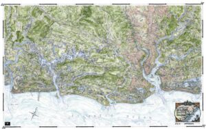
A General Plan of Edisto Island to Charleston, Late 19th Century South Carolina
South Carolina
$
170.00
Details
A General Plan of South Carolina—The Grand Strand—Pawleys Island to Myrtle Beach
South Carolina
$
190.00
Details
South Carolina Sea Islands—Capers Island to Cat Island
South Carolina
$
170.00
Details
South Carolina Sea Islands—Daufuskie Island to Fripp Island
South Carolina
$
170.00
Details
South Carolina Sea Islands—Edisto Island to Isle of Palms
South Carolina
$
170.00